


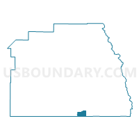
Voting District 55290, Tulare County, California
About
Outline

Summary
| Unique Area Identifier | 545700 |
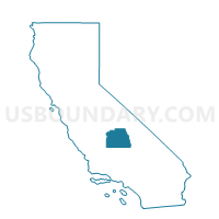
| Name | Voting District 55290 |
| County | Tulare County |
| State | California |
| Area (square miles) | 19.93 |
| Land Area (square miles) | 19.93 |
| Water Area (square miles) | 0.00 |
| % of Land Area | 100.00 |
| % of Water Area | 0.00 |
| Latitude of the Internal Point | 35.81472240 |
| Longtitude of the Internal Point | -118.62306020 |
Maps

Graphs
Select a template below for downloading or customizing gragh for Voting District 55290, Tulare County, California


Neighbors
Neighoring Voting District (by Name) Neighboring Voting District on the Map
- Voting District 10000, Kern County, CA
- Voting District 10925, Kern County, CA
- Voting District 55435, Tulare County, CA
- Voting District 55455, Tulare County, CA
Top 10 Neighboring County Subdivision (by Population) Neighboring County Subdivision on the Map
Top 10 Neighboring Place (by Population) Neighboring Place on the Map
- Idlewild CDP, CA (43)
- Panorama Heights CDP, CA (41)
- Sugarloaf Saw Mill CDP, CA (18)
- McClenney Tract CDP, CA (10)
- Sugarloaf Village CDP, CA (10)
- Posey CDP, CA (10)
- Poso Park CDP, CA (9)
- Sugarloaf Mountain Park CDP, CA (0)
Top 10 Neighboring Elementary School District (by Population) Neighboring Elementary School District on the Map
- Kernville Union Elementary School District, CA (11,432)
- Ducor Union Elementary School District, CA (1,276)
- Linns Valley-Poso Flat Union School District, CA (612)
- Hot Springs Elementary School District, CA (317)
Top 10 Neighboring Secondary School District (by Population) Neighboring Secondary School District on the Map
- Kern Union High School District, CA (596,351)
- Porterville Unified (9-12) School District, CA (47,072)